
Camminando fra i borghi costieri It Eng
Cammino fra i borghi costieri
Walking along the sandy beach
Donnalucata è la più popolosa frazione marinara di Scicli, abitata tutto l’anno, che già in primavera vede l’arrivo di turisti e visitatori provenienti dal nord Europa. Tuttavia, da alcuni anni nel periodo invernale diviene sempre più luogo ove dalle fredde contrade del nord Italia giungono per godere del mare,dei tepori e dei buoni sapori mediterranei.
La camminata che vi proponiamo è un lungo relax sulla sabbia fine che unisce Donnalucata a Cava d’Aliga, interrotta soltanto dal guado del torrente Modica – Scicli, operazione che può divenire problematica nelle peggiori giornate invernali per chi proprio non voglia bagnarsi attraversando la foce lungo la battigia.
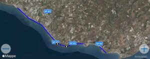
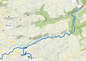
La tabella più sotto riporta le distanze a partire da una o dall’altra estremità e mette in evidenza le strutture ove poter prendere ristoro soprattutto, se possiamo permetterci il suggerimento, con una buona granita, eventualmente accompagnata da una brioche oppure, opzione nota ai più “esperti”, da un buon panino.
Le piazzette dove si trovano gli Chalet – come vengono qui chiamati gli stabilimenti balneari dotati di bar / pizzeria / ristorante e aperti in estate – o i Chioschi – piccole costruzioni di legno – rappresentano luoghi di parcheggio, anche se nella stagione estiva e in orari di punta non è sempre possibile lasciare l’auto vicino al mare. Diversa la situazione agli estremi del percorso, dove sono presenti più ampi parcheggi, segnalati sempre nella stessa tabella.
La sabbia, compatta, consente di camminare o addirittura di correre senza problemi per un ottimo allenamento di eco-running. al ritmo delle onde. Gli appassionati di itinerari in vicinanza del mare potranno fruire anche di alternative affascinanti (vedi le schede pubblicate su sito e quelle che pubblicheremo), ma in nessun altro caso potranno godere della prossimità delle onde come in questo. Allungare il passo non è un obbligo e procedendo con tranquillità prende forma una passeggiata diversa dalle altre e adatta a tutti, essendo lunga quasi 5 km la striscia di sabbia che unisce Donnalucata a Cava d’Alia, con la breve interruzione in corrispondenza della foce del torrente Modica Scicli.
Se il vostro itinerario comincia dalle baracche del Mercatino del Pesce di Donnalucata e se avete scelto un orario mattutino assisterete alle compravendite – forse farete un pensierino per un acquisto al ritorno – e soprattutto potrete gustare una prima colazione con granita o con gelato, poiché bar con gusti di buona qualità a Donnalucata non mancano certo. Lungo la strada e a destinazione potrete replicare, non mancando, come leggete nel riquadro, luoghi di ristoro.
Il consiglio, tuttavia, è di rientrare al tramonto verso Donnalucata, perché ai sapori della giornata si aggiungeranno i toni delle onde e i colori indimenticabili del cielo. Il mare del tramonto vi regalerà, se lo vorrete, un bagno parimenti indimenticabile.
giampaolo.schillaci@baroccoslowcoast.it
Walking along the sandy beach
Donnalucata is the most populous seaside hamlet of Scicli, inhabited all year round, which sees the arrival of tourists and visitors from northern Europe as early as spring. However, in recent years, during the winter months, it has increasingly become a destination for those travelling from the cold regions of northern Italy to enjoy the sea, the warmth and the flavours of the Mediterranean.
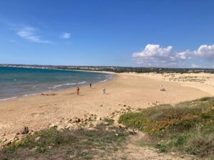
The walk we suggest is a long, relaxing stroll along the fine sand linking Donnalucata to Cava d’Aliga, interrupted only by the crossing of the Modica–Scicli stream – a task that can prove problematic on the worst winter days for those who simply do not wish to get wet whilst crossing the mouth of the stream along the shoreline.
The table below shows the distances from either end and highlights the places where you can stop for refreshments – above all, if we may suggest, with a good granita, perhaps accompanied by a brioche or, an option known to the more ‘experienced’, a tasty sandwich.
The small squares where the Chalet – as the beach establishments equipped with a bar/pizzeria/restaurant and open in summer are called here – or the ‘kioske’ – small wooden structures – are located serve as parking areas, although during the summer season and at peak times it is not always possible to leave your car near the sea. The situation is different at either end of the route, where there are larger car parks, always indicated on the same map.
The compact sand allows you to walk or even run without any problems, making for an excellent eco-running workout to the rhythm of the waves. Those who enjoy routes close to the sea will also find fascinating alternatives (see the guides published on the website and those we will publish), but nowhere else can you enjoy the proximity of the waves quite like here. There’s no need to pick up the pace; taking it easy creates a walk unlike any other and suitable for everyone, as the stretch of sand linking Donnalucata to Cava d’Alia is almost 5 km long, with a brief interruption at the mouth of the Modica Scicli stream.
If your itinerary begins at the stalls of the Donnalucata Fish Market and you’ve chosen a morning time, you’ll witness the buying and selling – perhaps you’ll consider a purchase on your return – and above all, you can enjoy breakfast with granita or ice cream, as there’s certainly no shortage of bars serving good-quality treats in Donnalucata. Along the way and at your destination, you can do the same, as there is no shortage of places to eat, as you can see in the box.
Our advice, however, is to return to Donnalucata at sunset, because the sounds of the waves and the unforgettable colours of the sky will add to the flavours of the day. The sea at sunset will treat you, if you wish, to an equally unforgettable swim.
giampaolo.schillaci@baroccoslowcoast.it
Coordinates: 36°46’43.46″ N – 14°35’35.06″ E
Enter, park your vehicle and walk the approach path: it is dirt parallel to the road (in green, about 250 m in all). After the short tunnel and the short uphill ramp, the loop begins, which most runners walk clockwise. The south side runs along the reedbed and meets a majestic olive tree before changing direction to the west (350 m from the start). We are running along the backdune path, surrounded by thick patches of Mediterranean vegetation, and we sense the presence of the sea. We will finally see it when we reach the base of the short pebbly tear that will test the legs imprisoned by the horizontal path.
When we reach the top (1.15 km) we turn right and our eye welcomes in wonder at the spectacle of the long beach. Immediately down and then slightly uphill, an “s” again downhill and a shady passage bring us back to the starting point, with a path that is pebbly in places compared to one that went on packed earth and sand.
In summer it is advisable to choose and morning and evening hours, in winter there are no time restrictions except those prescribed by the Reserve regulations. The Reserve is manned by staff of the Sicilian Region Forestry Company and is an interesting naturalistic area for flora and fauna, a welcome place for photography enthusiasts and for children, whose favorite pastime is to throw crumbs to the voracious fish that populate the small lake near the mouth.
giampaolo.schillaci@baroccoslowcoast.it

