
Le Gole della “Stretta” – Ita Eng
“Le Gole della Stretta” – Comune di Buccheri (Siracusa).
Attività: Trekking giornaliero – Bagno nel torrente – Torrentismo* (con attrezzature per la discesa) e Torrentismo soft (senz attrezzature) – Arrampicata su parete attrezzata* (* solo per esperti).
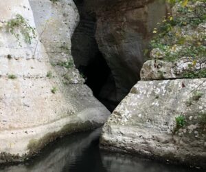
Descrizione. Le affascinanti “Gole della Stretta” o “Stretta di Buccheri” sono state scavate dall’azione erosiva delle acque del fiume San Leonardo, considerato il corso d’acqua più importante dell’area nord del territorio di Siracusa. Dopo aver percorso l’estremità settentrionale degli Iblei (nella quale sorge Buccheri) il San Leonardo bagna i territori a cavallo tra Francofonte e Lentini, dividendo idealmente la provincia aretusea da quella catanese, sfociando nello Ionio poco a sud del fiume Simeto, che cintura l’Etna da ovest a sud ed è il più importante fiume siciliano. Il tratto interessato scorre da sud a nord. Se arriverete da nord, dovrete risalire la corrente, inoltrandovi nella Stretta a nuoto o a bordo di un canotto. Giunti alla cascatella, dovrete ritornare indietro. Si tratterà pertanto di quello che abbiamo definito Torrentismo Soft. Se arriverete alle acque da sud e vorrete percorrere i 3 km canonici, dovrete munirvi di apposite attrezzature per affrontare alcuni dislivelli; ovviamente, dovrete essere in grado di armare le discese e di affrontarle secondo le corrette tecniche.
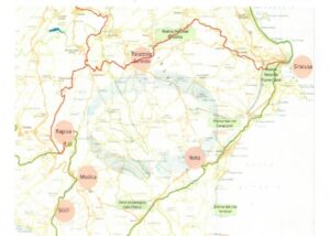
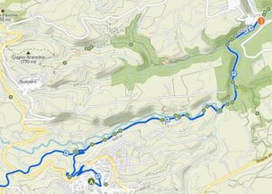
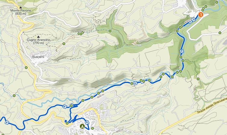
Come arrivare al torrente da nord. Viene descritto l’approccio da nord, tenendo conto che una volta giunti al corso d’acqua risalirete la corrente. Dunque, dal centro abitato di Buccheri si procede in direzione Pedagaggi – Catania, sulla SP 5 (detta “Strada San Giovanni”). A circa 6 km (6,8 km dalla piazza del paese) si incontra sulla sinistra l’agriturismo Terralivo. Circa 300 metri dopo, sullo stesso lato si imboccherà una piccola stradina asfaltata.
Coordinate dell’incrocio: 37°09’14.90”N – 14°53’25.59”E.
A circa 300 metri dall’imbocco troverete uno slargo, nel quale è possibile lasciare l’auto. Si proseguirà a piedi per circa 700 metri, prima in discesa e poi risalendo. Poco prima che la stradina curvi bruscamente a destra (in quel punto, ancora sulla destra, si trova una sbarra metallica posta a chiusura di una pista poderale), si troverà sulla sinistra un sentiero accennato, ma visibile, segnato da un “omino” di pietra talvolta nascosto dall’erba rigogliosa del ciglio della strada.
Coordinate dell’imbocco del sentiero: 37°09’31.57”N – 14°52’54.29”E, quota 515.
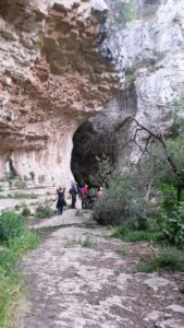
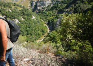
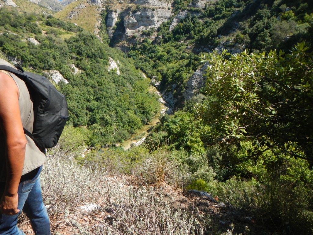
Seguendo la traccia, presto rinforzata da altri “omini”, e pur procedendo sulle rocce con la dovuta cautela specie se dopo una pioggia, in circa 20 minuti si arriverà al fondo valle.
L’escursione sul torrente. Giunti al corso d’acqua, la cui consistenza in quel tratto risente grandemente dell’andamento delle piogge (da asciutto a tumultuoso), passando sulla sponda idraulica sinistra si raggiungerà facilmente una marmitta profonda 5-6 metri, formata dalle acque di una cascatella, detta Uruvu (“laghetto”) di Sant’Antonio, poiché una leggenda locale narra che in questo minuscolo specchio d’acqua venne ritrovata la campana della vecchia Chiesa di Sant’Antonio, crollata in seguito del terremoto del 1693. Nelle ore più calde delle giornate estive si potranno alternare bagni rinfrescanti e pause al sole.
Invece, risalendo agevolmente il corso d’acqua lungo la sponda destra, prestissimo si perviene ad un grande riparo sotto roccia, segnato da numerose placche che segnano più vie di risalita per arrampicatori esperti. La gola diviene stretta e il cammino si interrompe: occorre risalire la corrente a nuoto, eventualmente appoggiandovi a un salvagente che vi sarete portati dietro, o utilizzando un canotto.
Non dimenticate di lasciare indumenti di ricambio in auto, ma nemmeno di portarvi panini e acqua nello zaino!
Per la conoscenza del territorio e di percorsi alternativi: Associazione Acquanuvena – Avola (SR) – www.acquanuvena.it – CAI, Sezione di Siracusa (SR) – www.caisiracusa.it (Giuseppe la Gumina e Gianni Bartocci).
NOTA 1 – Chi vorrà condurre una escursione sui luoghi dovrà informarsi autonomamente e non potrà in nessun modo riferire o addebitare eventuali contrattempi o incidenti a quanto riportato in questa scheda.
NOTA 2: Ripetiamo: la portata d’acqua nel torrente può essere notevole o molto bassa, dipende dalla piovosità stagionale. Si può accedere al torrente molto più a valle se si vuole effettuare la risalita senza attrezzature, o molto più a monte se si è provvisti di attrezzature per la discesa. Per questi itinerari chiedere al CAI Siracusa
Altri luoghi per il torrentismo soft in Sicilia sud est: fiume Tellaro (Noto – SR), fiume Cavagrande (Avola – SR), Fiume Calcinara (Sortino – SR).
giampaolo.schillaci@baroccoslowcoast.it
KJKJ ²
“The Stretta Gorges” – Municipality of Buccheri (Syracuse).
Activities: Day hikes – Swimming in the stream – Canyoning* (with descent equipment) and soft canyoning (without equipment) – Climbing on a bolted route* (* for experienced climbers only).
Description. The fascinating “Gole della Stretta” or “Stretta di Buccheri” were carved out by the erosive action of the waters of the River San Leonardo, considered the most important watercourse in the northern part of the Syracuse area. After flowing through the northernmost part of the Iblei mountains (where Buccheri is situated), the San Leonardo river flows through the territories straddling Francofonte and Lentini, effectively dividing the province of Syracuse from that of Catania, and empties into the Ionian Sea just south of the Simeto river, which encircles Mount Etna from west to south and is Sicily’s most important river. The section in question flows from south to north. If you arrive from the north, you will need to go upstream, entering the Stretta either by swimming or in a dinghy. Once you reach the small waterfall, you will need to turn back. This will therefore be what we have termed ‘Soft Canyoning’. If you arrive at the water from the south and wish to cover the standard 3 km, you will need to equip yourself with the appropriate gear to tackle some elevation changes; obviously, you must be able to set up the descents and tackle them using the correct techniques.
How to reach the stream from the north. The approach from the north is described, bearing in mind that once you reach the watercourse, you will be going upstream. So, from the village of Buccheri, head towards Pedagaggi – Catania on the SP 5 (known as the “Strada San Giovanni”). After about 6 km (6.8 km from the village square), you will see the Terralivo farmhouse on your left. About 300 metres further on, on the same side, take a small tarmac road.
Coordinates of the junction: 37°09’14.90”N – 14°53’25.59”E.
About 300 metres from the turn-off, you will find a lay-by where you can leave your car. Continue on foot for about 700 metres, first downhill and then uphill. Just before the road bends sharply to the right (at that point, still on the right, there is a metal barrier blocking a farm track), you will find a faint but visible path on the left, marked by a stone cairn sometimes hidden by the lush grass at the roadside.
Coordinates of the path entrance: 37°09’31.57”N – 14°52’54.29”E, altitude 515 m.
Following the trail, which is soon reinforced by other cairns, and proceeding with due caution over the rocks – especially after rain – you will reach the valley floor in about 20 minutes.
The walk along the stream. Once you reach the watercourse, the flow of which in this stretch varies greatly depending on rainfall (from dry to torrential), crossing over to the left bank will easily take you to a 5–6-metre-deep pothole, formed by the waters of a small waterfall known as Uruvu (“little lake”) of Sant’Antonio, as a local legend tells that the bell of the old Church of Sant’Antonio, which collapsed following the earthquake of 1693, was found in this tiny pool of water. During the hottest hours of summer days, you can alternate between refreshing dips and breaks in the sun.
Alternatively, by following the stream easily upstream along the right bank, you will soon reach a large rock shelter, marked by numerous plaques indicating several climbing routes for experienced climbers. The gorge narrows and the path ends: you will need to swim upstream, perhaps using a life jacket you have brought with you, or by using a small boat.
Don’t forget to leave a change of clothes in the car, and be sure to pack sandwiches and water in your rucksack!
For information on the area and alternative routes: Associazione Acquanuvena – Avola (SR) – www.acquanuvena.it – CAI, Syracuse Section (SR) – www.caisiracusa.it (Giuseppe la Gumina and Gianni Bartocci).
NOTE 1 – Anyone wishing to lead an excursion to these locations must make their own enquiries and may under no circumstances attribute any mishaps or accidents to the information provided in this guide.
NOTE 2: We repeat: the water flow in the stream can be substantial or very low, depending on seasonal rainfall. The stream can be accessed much further downstream if you wish to ascend without equipment, or much further upstream if you are equipped for the descent. For these routes, please contact CAI Syracuse
Other locations for soft canyoning in south-east Sicily: the Tellaro River (Noto – SR), the Cavagrande River (Avola – SR), the Calcinara River (Sortino – SR).

