
Cava Tortorone – Ita Eng
“Cava Tortorone” – Comune di Noto (Siracusa)
Attività: Acquatrekking
Prendetevi una intera mattina, compresa la sosta con bagno al laghetto terminale, per un cammino in acqua che vi divertirà senza sottoporvi a particolari difficoltà o pericoli oltre a quelli insiti all’acquatrekking e al trovarsi in fondo ad una cava con le comunicazioni ridotte o impossibili in caso di bisogno. Siate sempre non meno di tre e seguite le norme di sicurezza per l’Escursionismo. Nelle annate siccitose il torrente potrebbe essere completamente a secco!
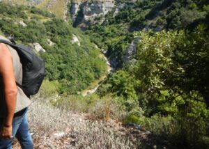
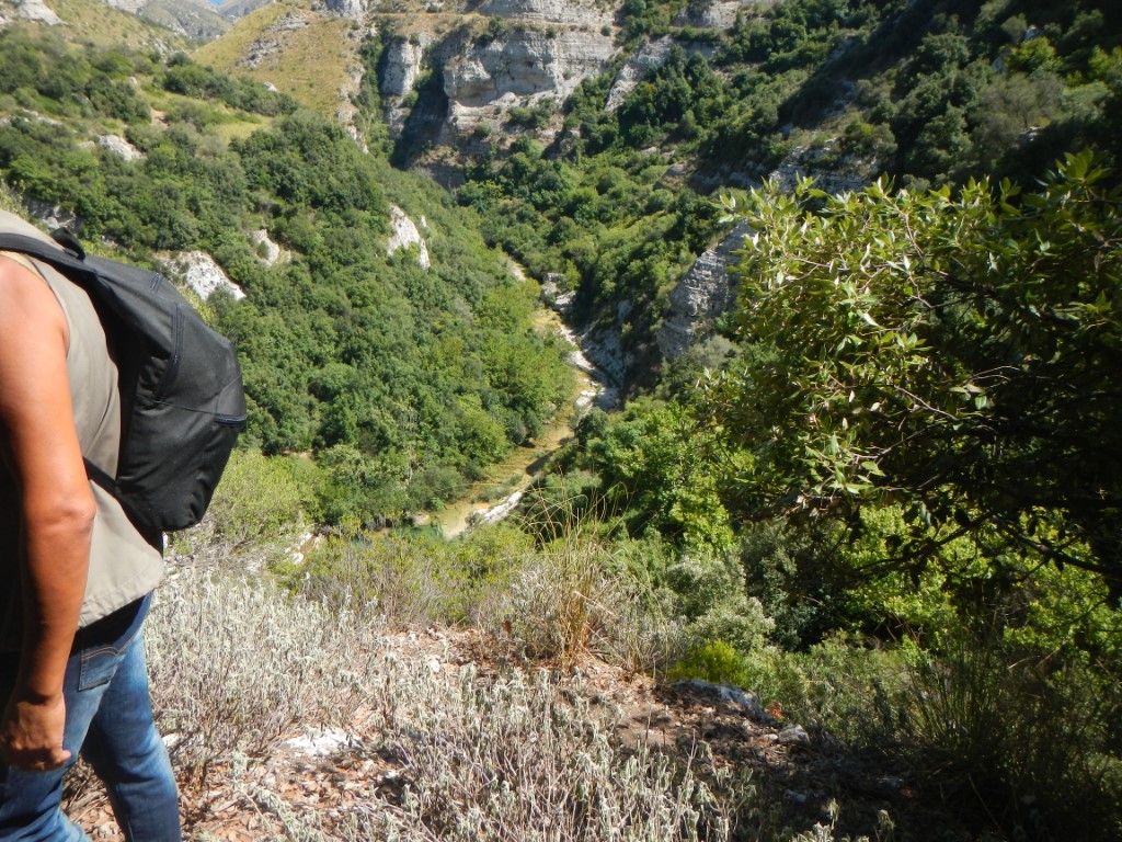
Descrizione. Il Torrente Santa Chiara è un affluente di sinistra del fiume Asinaro. Prima della confluenza dà origine alla Cava Tortorone, con pareti strapiombanti. Conclude il percorso una profonda marmitta dove farete un bel bagno; soltanto gli escursionisti esperti muniti di adeguate attrezzature da discesa potranno proseguire oltre.
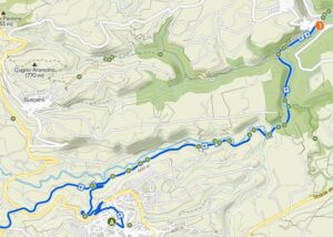
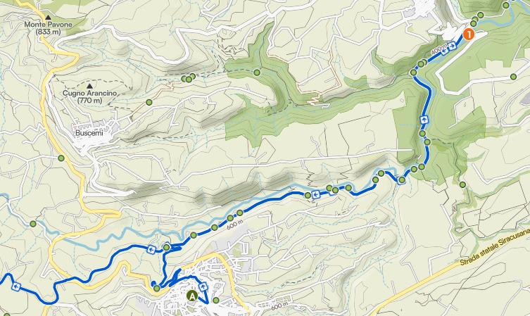
Come arrivare al torrente. Si segue la SS 287, alla quale si può accedere sia da sud (Noto) che da nord (Palazzolo Acreide). Procedendo da Noto verso Palazzolo, il bivio per l’Eremo di San Corrado, che si incontra a sinistra, dista circa 4 km dall’Ospedale della città. Poco dopo avere imboccato la strada che porta all’Eremo, girerete a destra per la prima strada asfaltata, che seguirete sino al primo bivio, dove girerete a destra per lasciare le auto appena possibile.
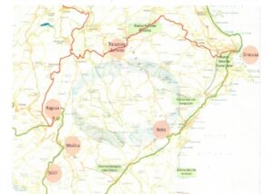
Coordinate dell’incrocio fra la SS 287 e la stradella che porta all’Eremo: 36°56’5.80″N – 15° 3’34.80″E (v. figura).
Coordinate dello slargo in discesa dove potrete parcheggiare: 36°55’57.57″N – 15° 3’24.86″E – 323 mslm.
Da qui raggiungerete l’acqua in poco meno di 700 metri di cammino in discesa, incontrando il corso d’acqua a circa 273 mslm.
KJKJ ²
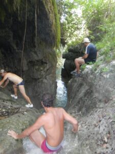
L’escursione sul torrente. Comincia ora il vostro acqua-trekking, con il percorso che si snoda nel fondovalle dove scorrono acque limpide e fresche, e che seguendo la corrente vi porterà in circa 90 minuti al laghetto terminale. Il cammino è in acqua per l’intero percorso, anche se sulle sponde troverete, ma solo in due casi, passaggi che vi eviteranno un bagno completo, se proprio desiderate rinviarlo al laghetto terminale. Tranne che in questi due casi, le sponde non sono percorse da sentieri o comunque percorribili.
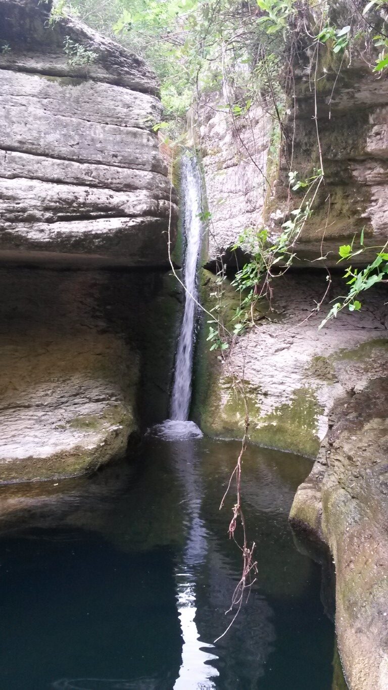
Nella marmitta l’acqua si versa con un breve piano inclinato e una gradevole cascatella finale. A voi la scelta di fare scivolo con il sedere, oppure tuffarvi con cautela da una delle rocce sovrastanti oppure ancora raggiungere il bordo ovest del laghetto attraverso uno stupefacente cunicolo scavato, chissà da chi e quanto tempo fa, all’interno della parete calcarea che lo delimita. In ogni caso, massima attenzione nel praticarne il bordo, stante il pericoloso precipizio che si trova dall’altro lato e che rappresenta il pericolo maggiore dell’escursione.
Non dimenticate di lasciare indumenti di ricambio in auto e di portarvi dietro acqua e cibo, meglio se nella sacca impermeabile da acqua-trekking.
NOTA 1 – Chi vorrà andare al Tortorone dovrà informarsi autonomamente e non potrà in nessun modo riferire o addebitare eventuali contrattempi o incidenti a quanto riportato in questa scheda. Ricordatevi che una volta in fondo alla cava non potrete fare conto sui cellulari, perciò anche una banale storta può diventare un problema.
Altri luoghi per il torrentismo soft in Sicilia sud est: fiume Tellaro (Noto – SR), fiume Cavagrande (Avola – SR), Fiume Calcinara (Sortino – SR), Cava Prainito (SR) e altri ancora.
“Cava Tortorone” – Municipality of Noto (Syracuse).
Activities: water trekking
Set aside a whole morning, including a stop for a swim at the final pool, for a walk in the water that will be enjoyable without exposing you to any particular difficulties or dangers beyond those inherent in water trekking and being at the bottom of a quarry with limited or no means of communication in case of need. Always go in a group of at least three and follow the safety guidelines for hiking. Please follow the safety guidelines for hiking. In dry years, the stream may be completely dry!
Description. The Santa Chiara stream is a left-hand tributary of the Asinaro river. Before the confluence, it forms the Cava Tortorone, with sheer walls. The route ends at a deep pothole where you can enjoy a lovely swim; only experienced hikers equipped with suitable descent gear may continue beyond this point.
How to get to the stream. Follow the SS 287, which can be accessed from both the south (Noto) and the north (Palazzolo Acreide). Travelling from Noto towards Palazzolo, the turn-off for the Hermitage of San Corrado, which is on the left, is about 4 km from the town’s hospital. Shortly after turning onto the road leading to the Hermitage, turn right onto the first tarmac road, which you should follow until the first junction, where you should turn right and park your cars as soon as possible.
Coordinates of the junction between the SS 287 and the small road leading to the Hermitage: 36°56’5.80‘N – 15° 3’34.80’E (see figure).
Coordinates of the widening on the descent where you can park: 36°55’57.57‘N – 15° 3’24.86’E – 323 m a.s.l.
From here, you will reach the water after a descent of just under 700 metres, coming to the stream at approximately 273 m a.s.l.
The stream hike. Your water trek begins now, with the route winding through the valley floor where clear, cool waters flow, and following the current will take you to the terminal pond in about 90 minutes. The path is in the water for the entire route, although on the banks you will find, in just two places, sections that will allow you to avoid a full dip, if you really wish to save that for the final pond. Apart from these two places, the banks are not traversed by paths or otherwise passable.
In the pothole, the water flows down a short slope and ends in a pleasant little waterfall. It’s up to you whether to slide down on your bottom, dive carefully from one of the overhanging rocks, or reach the western edge of the pond via an astonishing tunnel carved – who knows by whom and how long ago – into the limestone wall that borders it. In any case, exercise the utmost caution when walking along the edge, given the dangerous precipice on the other side, which poses the greatest danger of the hike.
Don’t forget to leave a change of clothes in the car and to bring water and food with you, preferably in a waterproof water-trekking bag.
Cultural associations: Acquanuvena – Avola (SR) – www.acquanuvena.it
NOTE 1 – Anyone wishing to visit Tortorone must make their own enquiries and may under no circumstances attribute any mishaps or accidents to the information provided in this guide. Remember that once at the bottom of the quarry, you will not be able to rely on mobile phones, so even a minor misstep can become a problem.
Other locations for soft canyoning in south-east Sicily: the Tellaro River (Noto – SR), the Cavagrande River (Avola – SR), the Calcinara River (Sortino – SR), Cava Prainito (SR) and others.
giampaolo.schillaci@baroccoslowcoast.it

